Mapa grabado (55×45 cm)
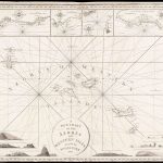
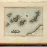
Pertenece a la obra ‘A new general atlas, consisting of a series of geographical designs, on various projections, exhibiting the form and component parts of the globe; and a collection of maps and charts, delineating the natural and political divisions of the empires, kingdoms, and states in the World’, bajo el nombre ‘Atlantic islands. Cape Verd Ids. Canary Ids. Azore Ids. Madeira Ids. (with) Road of Rayal with Porto Pin in the island of Fayal. (with) Puerto de Naos and Puerto Cavillo in the isle of Lancarota. (with view) The peak of Teneriffe’. Cuatro mapas grabados en 1 hoja, con 2 mapas insertados y 1 vista de los archipiélagos atlánticos de la Macaronesia, comprendidos por Cabo Verde, Islas Canarias, Madeira e islas Azores.
| Autor: | Thomson, John |
|---|---|
| Año: | 1817 |
| Fuente: | David Rumsey Map Collection Database and Blog. List No. 100.055. Series No. 59. Reference: P731; Newberry Library: Ayer +135 T4 1817. |