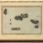
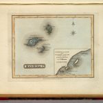
Mapa manuscrito (23×27 cm)
Pertence a la obra ‘A General Atlas Containing Distinct Maps Of all the Known Countries in the World, Constructed from the Latest Authority’, bajo el nombre de ‘Cape Verd Ids. B.T. Welch & Co. Sc. Published by F. Lucas Jr. Baltimore’. En él, aparecen las islas de Cabo Verde coloreadas en azul sobre un fondo claro.
| Autor: | Lucas, Fielding Jr. |
|---|---|
| Año: | 1823 |
| Fuente: | David Rumsey Map Collection Database and Blog. List No. 4584.042. Series No: 46. |