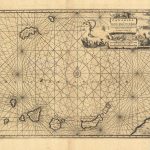
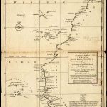
Mapa grabado (25,4×17,8 cm)
Pertenece a la obra ‘Atlas minor: or a new and curious set of sixty-two maps, in which are shewn all the empires, kingdoms, countries, states, in all the known parts of the earth; with their bounds, divisions, chief cities & towns, the whole composed & laid down agreable to modern history’, bajo el nombre ‘A map of Zaara or the Desart, Negroland & Cape Virde Islands’. Un mapa grabado de África Occidental que incluye las Islas Canarias y las Islas de Cabo Verde.
| Autor: | Moll, Herman |
|---|---|
| Año: | 1735 |
| Fuente: | Colección: Proyecto Patrimonios Insulares. |